


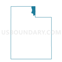
Woodruff Voting District, Rich County, Utah
About
Outline

Summary
| Unique Area Identifier | 678965 |
| Name | Woodruff Voting District |
| County | Rich County |
| State | Utah |
| Area (square miles) | 420.51 |
| Land Area (square miles) | 418.65 |
| Water Area (square miles) | 1.85 |
| % of Land Area | 99.56 |
| % of Water Area | 0.44 |
| Latitude of the Internal Point | 41.40358510 |
| Longtitude of the Internal Point | -111.23401860 |
Maps


Graphs
Select a template below for downloading or customizing gragh for Woodruff Voting District, Rich County, Utah


Neighbors
Neighoring Voting District (by Name) Neighboring Voting District on the Map
- ALMY HILLIARD Voting District, Uinta County, WY
- Croydon, Morgan County, UT
- Echo Voting District, Summit County, UT
- Huntsville 2A Voting District, Weber County, UT
- Oakley Voting District, Summit County, UT
- Randolph South Voting District, Rich County, UT
- Unpopulated Voting District, Cache County, UT
Top 10 Neighboring County Subdivision (by Population) Neighboring County Subdivision on the Map
- Evanston CCD, Uinta County, WY (14,613)
- Morgan North CCD, Morgan County, UT (8,042)
- Ogden Valley CCD, Weber County, UT (6,604)
- Coalville CCD, Summit County, UT (4,865)
- Randolph-Woodruff CCD, Rich County, UT (1,038)
- East Cache CCD, Cache County, UT (105)
Top 10 Neighboring Place (by Population) Neighboring Place on the Map
Top 10 Neighboring Unified School District (by Population) Neighboring Unified School District on the Map
- Weber School District, UT (148,422)
- Cache School District, UT (64,634)
- Uinta County School District 1, WY (14,618)
- Morgan School District, UT (9,469)
- South Summit School District, UT (7,001)
- North Summit School District, UT (4,922)
- Rich School District, UT (2,264)
Top 10 Neighboring State Legislative District Lower Chamber (by Population) Neighboring State Legislative District Lower Chamber on the Map
- State House District 5, UT (43,319)
- State House District 53, UT (37,757)
- State House District 8, UT (32,064)
- State House District 19, WY (8,191)
Top 10 Neighboring State Legislative District Upper Chamber (by Population) Neighboring State Legislative District Upper Chamber on the Map
- State Senate District 19, UT (91,855)
- State Senate District 25, UT (89,262)
- State Senate District 15, WY (16,793)
Top 10 Neighboring 111th Congressional District (by Population) Neighboring 111th Congressional District on the Map
Top 10 Neighboring Census Tract (by Population) Neighboring Census Tract on the Map
- Census Tract 9701, Morgan County, UT (8,042)
- Census Tract 9753, Uinta County, WY (7,761)
- Census Tract 2101, Weber County, UT (6,942)
- Census Tract 9754, Uinta County, WY (6,852)
- Census Tract 9501, Rich County, UT (2,264)
- Census Tract 9641.01, Summit County, UT (2,052)
- Census Tract 9801, Cache County, UT (105)